There is a variety of tours and places of interest for day visitors as well as those staying longer. Bushwalking, 4WD touring and camping are all popular pastimes.
Refer to the 'Valleys and Bluffs - car tours and walks around Wabonga Plateau, Mt Cobbler and Powers Lookout' Park Note for a detailed map and further information about this area.
Getting there
Mount Cobbler and the Wabonga Plateau area of the Alpine National Park are best approached from Whitfield.
From Melbourne, Whitfield can be reached via the Hume Highway to Wangaratta or via the Maroondah Highway to Mansfield and then via Tolmie.
Roads from Benalla, Mansfield and Myrtleford also provide interesting scenic routes to the area. The distance between Melbourne and Whitfield is 260 kilometres.
Take care
Weather conditions can change rapidly in alpine areas. Snowfalls can be experienced at Mount Cobbler at any time of the year and water can be extremely scarce, so always be prepared with:
- warm clothing
- wind and waterproof jacket
- gloves, hat, sunglasses and strong footwear
- first aid kit and sunscreen
- high energy food and water
- compass and relevant topographical map.
Setting up camp
For car-based campers, there are sites with facilities at Lake Cobbler. Four wheel drive access is recommended. It is very rough for two wheel drives past Bennies.
When camping please keep vehicles to formed tracks, and be fully self sufficient with food, water, firewood and camping equipment. Always carry a tent. Huts are for emergency use only.
Huts
There are many huts throughout the Wabonga Plateau - Mount Cobbler area, built by early graziers, privately for recreation or by the former Forestry and Lands Departments.
The present Lake Cobbler Hut was built in 1986 by the Wangaratta 4WD Club. The original hut was built in the early 1900s as part of the Lovick grazing licence, followed by another built by Sam Christopher and Frank Gorman who had the Cobbler grazing licence from 1929 to the 1940s.
Enjoy a visit to a hut but do not rely on them for accommodation.
Scenic drives
Lake Cobbler (48 km from Whitfield)
There is very rough 2WD access as far as Bennies in dry weather only
A scenic drive passing through the picturesque farming valley of the Rose River, riverine forest and foothill bushland before ascending to the sub-alpine woodlands of Lake Cobbler. You will pass by the impressive pink sandstone and conglomerate slopes of Mount Typo and Bennies, a quiet bush camping area beside the Rose River. This camp is named after Allan Bennie who ran fishing trips for walkers and horse riders. The last section of road provides dramatic glimpses of the Dandongadale Falls (Victoria's longest falls with a 255m drop), tumbling off the Cobbler Plateau.
Return the same way or take the Little Cobbler Track to the remote King River area. Please keep to formed roads.
Walks
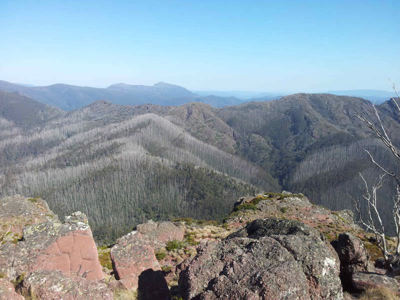
Mt Cobbler
10 kms, 3.5 hours return
Mount Cobbler is an exposed, rocky alpine summit, so be prepared for the onset of cold, wet and windy conditions at any time of the year.
From the camping area at Lake Cobbler the walking track enters the forest and dips into a moist creek gully, before starting the steady and sometimes steep climb to an open snow plain area.
At the 'T' intersection turn right (north) to Mount Cobbler peak. The other walking track returns to a 4WD track across the Cobbler Plateau. The walk to the summit is well worthwhile for both the views and wildflowers you will encounter along the way. A moderate walk with some steep sections.
Mount Cobbler to Mt Speculation
A remote walk along an indistinct footpad links the Cobbler Plateau with Mount Speculation. Mt Koonika can be included in this hike. Alternatively (if you have a 4WD) drive along the Mount Speculation Road to Camp Creek on the edge of the wilderness. Many extended walks can be undertaken from the Mount Speculation area.